GEOTECHNICAL ENGINEERING
LAREDO
HomeGeophysicsElectrical resistivity / VES (Vertical Electrical Sounding)

Electrical Resistivity Testing & Vertical Electrical Sounding in Laredo

Knowledgeable. Thorough. Resourceful.

LEARN MORE

Laredo’s expansion from a colonial crossing point into the busiest inland port in the United States has pushed development onto the intricate fluvial terraces of the Rio Grande. The city’s population, now over 260,000, demands infrastructure that must contend with heterogeneous alluvial deposits, expansive clays, and variable groundwater perched above the Carrizo-Wilcox aquifer. In our experience, relying solely on mechanical borings in this transitional geology often leaves critical gaps in the subsurface profile. Vertical Electrical Sounding (VES) fills those gaps by measuring the bulk resistivity response of the soil and rock column, distinguishing between saturated silts, dry sands, and the underlying shale bedrock without the disturbance of drilling. For Laredo’s commercial projects near the river or infrastructure corridors along I-35, this non-invasive method provides a stratigraphic backbone that helps us target the right locations for subsequent SPT drilling and sampling campaigns.

A resistivity survey across Laredo’s alluvial terraces can map a hidden paleochannel in an afternoon—before the first shovel breaks ground.
Our service areas

Methodology and scope

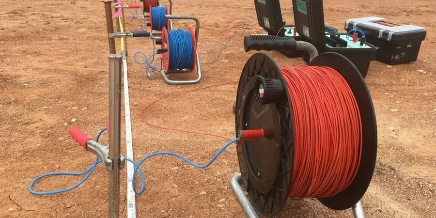
At an elevation of just 438 feet, Laredo sits on a sequence of Quaternary alluvium and Tertiary formations where the electrical contrast between units is often pronounced. A sandy channel fill might read over 200 ohm-m while an adjacent clay lens drops the response below 20 ohm-m—a signature we map continuously with a Schlumberger array. We run current electrode spacings from 1.5 meters out to 200 meters, building a one-dimensional resistivity sounding that reaches depths of 60 to 80 feet for typical building investigations. The field acquisition follows ASTM D6431, with our team using a Syscal Pro unit and stainless-steel stakes to ensure low contact resistance in the caliche-rich soils common across Webb County. Data inversion with IPI2Win software generates layered models that correlate directly with borehole logs, giving the geotechnical engineer a clear picture of where the water table sits, how thick the compressible layers are, and whether paleochannels cut through the building pad. Because we work frequently on sites where the Eagle Ford Shale weathers unevenly, the resistivity contrast between intact and degraded rock becomes a reliable indicator of excavation difficulty.
Electrical Resistivity Testing & Vertical Electrical Sounding in Laredo
Technical reference — Laredo

Site-specific factors

The most common oversight we see in Laredo is treating the entire site as a uniform clay basin and skipping geophysical profiling before placing borings. A single boring in a silty paleochannel may miss the expansive El Pico Clay lens just 20 feet away—leading to differential movement that shows up within the first two wet-dry cycles. Resistivity sounding catches that lens because the clay’s low resistivity signature stands out sharply against the surrounding sand. In our experience, the cost of repairing slab distress on a tilt-wall warehouse near Mines Road far exceeds the investment in a targeted VES survey during the design phase. The IBC requires that foundation recommendations be based on adequate subsurface information; when borings are sparse, resistivity data provides the continuity that satisfies the standard of care.

Need a geotechnical assessment?

Reply within 24h.

Email: contact@geotechnical-engineering1.org

Explanatory video

Regulatory framework

ASTM D6431-18 Standard Guide for Using the Direct Current Resistivity Method for Subsurface Site Characterization, IBC 2021 Section 1803 Geotechnical Investigations, ASCE 7-22 Chapter 20 Site Classification Procedure

Typical values

ParameterTypical value
Array ConfigurationSchlumberger (standard), Wenner (for lateral resolution)
Maximum Depth of Investigation60 to 100 ft (typical), up to 150 ft with expanded spreads
Current Electrode Spacing (AB/2)1.5 m to 200 m
Resistivity Range0.1 ohm-m (saline clays) to 10,000 ohm-m (dry caliche/limestone)
Data Acquisition StandardASTM D6431-18
Inversion SoftwareIPI2Win, Res2DInv (for 2D profiles)
Typical Survey Duration2 to 4 hours per sounding
Target Geologic UnitsQuaternary alluvium, Laredo Formation, El Pico Clay, Eagle Ford Shale

Common questions

How much does a resistivity survey cost for a typical commercial lot in Laredo?

For a standard VES sounding and interpretation on a commercial lot within Webb County, our fees generally range from US$670 to US$1.150. The final cost depends on the number of soundings, the maximum depth required, and the complexity of the terrain. A 2D ERT line will be priced separately based on length. We provide a fixed-price proposal after reviewing the site location and project scope.

Can resistivity testing tell the difference between the El Pico Clay and the Laredo Formation?

Yes, and that distinction is one of the primary reasons we run VES in Laredo. The El Pico Clay, part of the Jackson Group, typically exhibits a very low resistivity signature—often below 10 ohm-m—due to its high plasticity and moisture retention. The underlying Laredo Formation sandstone and siltstone show much higher resistivity, commonly between 50 and 150 ohm-m. The sharp contrast at the contact makes this an ideal target for electrical sounding, and we calibrate the geophysical contact with at least one borehole to confirm the boundary.

What depth can a VES survey reach in the alluvial soils near the Rio Grande?

We routinely achieve investigation depths of 60 to 80 feet with a maximum current electrode spread of 200 meters. If the project requires a deeper look—for instance, to characterize the top of the Carrizo Sand for a water well or deep foundation—we can extend the AB/2 spacing to 400 meters, pushing the effective depth past 150 feet. However, the vertical resolution decreases with depth, so we discuss the trade-off between penetration and resolution during survey design.

Location and service area

We serve projects in Laredo and surrounding areas. More info.

View larger map